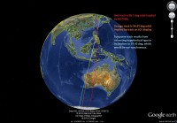
A lucky close-up of a computer screen in TV pictures from the Sohae launch facility is providing further clues as to the true launch trajectory of North Korea’s Unha-3 rocket launch.
[This story has been updated, see below]
The shot, included in pictures broadcast by Russia Today (see below), appears to show the satellite’s orbital path on a computer screen. It begins at the top of the image (click for a better view) and sweeps down across North Korea traveling southwards until it skirts the western coast of Mindanao and travels onwards to cross Australia’s eastern tip.


When putting a satellite into solar-synchronous orbit, the launch path needs to be inclined at 97.4 degrees, but North Korea’s notifications to international organization implied a launch path inclination of 88.7 degrees. That’s some way off the path the rocket needs to be taking.
Based on the TV image, Molczan revised his prediction to 94.5 degree inclination.
The orbit is not sun-synchronous, but better than the 88.7 deg orbit implied by the NOTAMs, for the stated purpose of the satellite. — Ted Molczan on SeeSat-L, April 11, 2012.
The trajectories are working on the assumption that the third stage of the rocket will shift its trajectory to put it on a new path.
And there’s a possibility the launch track could be right on target for a solar-synchronous orbit:
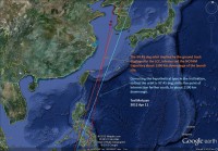
To be precisely sun-synch, a 500 km orbit must be inclined 97.4 deg. The apparent nearly 3 deg deficit may be an indication of the performance limitation of the launcher. I do not exclude the possibility that the displayed track was faked to mislead the news media, but it should not have been more difficult to produce a high-fidelity fake, assuming the work was done by the trajectory specialists. Considering the relative position of the numerals 4 and 7 on a keypad, a simple, honest typo also cannot be excluded. — Ted Molczan on SeeSat-L, April 11, 2012.
So, could a typo be throwing us off? And, if so, let’s hope it doesn’t make it into the actual launch systems.
Building on the typo hypothesis, if the ground track displayed in the launch control centre resulted from a set of orbital elements with a typo affecting a single digit of the inclination, such that 97.45 was entered as 94.45, then the true orbit can be recovered from the TLE I estimated from the track, simply by correcting the typo. Here is the TLE with the supposed typo: — Ted Molczan on SeeSat-L, April 11, 2012.
Here are the two images he’s referring to. Click to get a better view.


Update: Satellite watchers now believe they misinterpreted the TV images and, in fact, the launch track looks good for a solar synchronous orbit:


